
קובץ:US speed limits.svg

גודל התצוגה המקדימה הזאת מסוג PNG של קובץ ה־SVG הזה: 800 × 370 פיקסלים. רזולוציות אחרות: 320 × 148 פיקסלים | 640 × 296 פיקסלים | 1,024 × 474 פיקסלים | 1,280 × 593 פיקסלים | 2,560 × 1,185 פיקסלים | 1,268 × 587 פיקסלים.
לקובץ המקורי (קובץ SVG, הגודל המקורי: 1,268 × 587 פיקסלים, גודל הקובץ: 527 ק"ב)
זהו קובץ שמקורו במיזם ויקישיתוף. תיאורו בדף תיאור הקובץ המקורי (בעברית) מוצג למטה
ויקישיתוף הוא מאגר תמונות וקובצי מדיה חופשיים. אתם יכולים לעזור. |
תקציר
| תיאור |
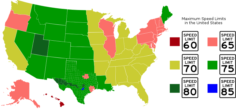
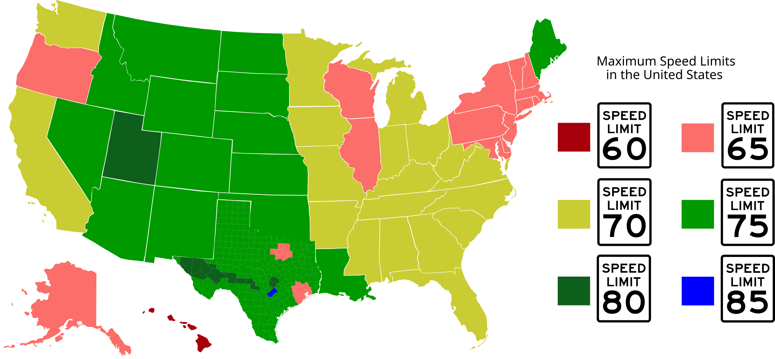
Top speed limits in the United States; lightest red color (Hawaii) is 60 mph, darkest green color (certain counties in Texas) is 80 mph. Entire state is one color if the top speed limit is broadly applicable. States may be graphically split into regions if different top speed limits exist in substantially-sized regions (generally larger than urban areas). From Blank_US_Map.svg (by Wikicommons user Theshibboleth) and Texas county map, also available on Wikipedia. Map colored by Shadowlink1014 and novasource. |
| תאריך יצירה | 18 במרץ 2007 (תאריך העלאה מקורי) |
| מקור | הועבר מ- en.wikipedia לוויקישיתוף. |
| יוצר |
Shadowlink1014 מוויקיפדיה האנגלית Later versions were uploaded by Novasource at en.wikipedia. |
| גרסאות אחרות | Derivative works of this file: US speed limits12.png |
רישיון
Shadowlink1014 מוויקיפדיה האנגלית, בעל זכויות היוצרים על היצירה הזאת, מפרסם אותה בזאת תחת הרישיון הבא:
| הקובץ הזה מתפרסם לפי תנאי רישיון קריאייטיב קומונז ייחוס-שיתוף זהה 3.0 לא מותאם. Subject to disclaimers. | ||
| ייחוס: Shadowlink1014 מוויקיפדיה האנגלית | ||
| ||
| תבנית רישוי זו הוספה לקובץ כחלק מעדכון רישיון GFDL. |

|
מוענקת בכך הרשות להעתיק, להפיץ או לשנות את המסמך הזה, לפי תנאי הרישיון לשימוש חופשי במסמכים של גנו, גרסה 1.2 או כל גרסה מאוחרת יותר שתפורסם על־ידי המוסד לתוכנה חופשית; ללא פרקים קבועים, ללא טקסט עטיפה קדמית וללא טקסט עטיפה אחורית. עותק של הרישיון כלול בפרק שכותרתו הרישיון לשימוש חופשי במסמכים של גנו. Subject to disclaimers. |
יומן העלאה מקורי
תיאור הקובץ המקורי נמצא כאן. כל שמות המשתמשים הבאים מתייחסים ל-en.wikipedia.
- 2007-04-28 02:10 Novasource 1300×593×0 (828888 bytes) Probably more correct interpretation of Virginia. In fact, max limit is 65 except for one small interstate.
- 2007-03-24 22:15 Shadowlink1014 1300×593×0 (828630 bytes) Top speed limits in the United States; darkest red color (Hawaii) is 60 mph, darkest green color (certain counties in Texas) is 80 mph. From Blank_US_Map.svg (by Wikicommons user Theshibboleth) and Texas county map, also available on Wikipedia. Map colo
- 2007-03-24 22:11 Shadowlink1014 1300×593×0 (828617 bytes) Top speed limits in the United States; darkest red color (Hawaii) is 60 mph, darkest green color (certain counties in Texas) is 80 mph. From Blank_US_Map.svg (by Wikicommons user Theshibboleth) and Texas county map, also available on Wikipedia. Map colo
- 2007-03-23 18:31 Novasource 1300×593×0 (828617 bytes) More corrections based on discussion with others.
- 2007-03-23 14:18 Novasource 1300×593×0 (828617 bytes) Fixed some Texas counties based on input of a person who had recently driven them. It should be noted that anecdotal experience suggests only a fraction of the eligible counties (the red ones at http://home.att.net/~texhwyman/h_imgs/txpopdens.jpg) have sp
- 2007-03-23 02:42 Novasource 1300×593×0 (631706 bytes) Newer version that incorporates individual Texas counties. Shows how little of Texas really is effected by the 80 mph speed limits. A more accurate version would have all the west Texas counties with 75 mph highlighting and thin lines to show I-20 and I-1
- 2007-03-18 21:33 Shadowlink1014 1300×593×0 (151903 bytes) Top speed limits in the United States; lightest color (Hawaii) is 60 mph, darkest color (Texas) is 80 mph. From Blank_US_Map.svg (by Wikicommons user Theshibboleth). Map colored by Shadowlink1014. == Licensing == {{self|GFDL}}
- 2007-03-18 21:26 Shadowlink1014 1300×593×0 (151314 bytes) Top speed limits in the United States. From Blank_US_Map.svg (by Wikicommons user Theshibboleth). Speed limit sign SVGs from WikiCommons. Data source: [[Speed limits in the United States]] Map colored by Shadowlink1014. == Licensing == {{self|GFDL}}
- 2007-03-18 20:48 Shadowlink1014 959×593×0 (90602 bytes) Top speed limits in the United States; lightest color (Hawaii) is 60 mph, darkest color (Texas) is 80 mph. From Blank_US_Map.svg (by Wikicommons user Theshibboleth). Map colored by Shadowlink1014. == Licensing == {{self|GFDL}}
היסטוריית הקובץ
ניתן ללחוץ על תאריך/שעה כדי לראות את הקובץ כפי שנראה באותו זמן.
| תאריך/שעה | תמונה ממוזערת | ממדים | משתמש | הערה | |
|---|---|---|---|---|---|
| נוכחית | 19:03, 4 בספטמבר 2012 | | 587 × 1,268 (527 ק"ב) | Novasource | Oops, prior version was cropped. |
| 19:01, 4 בספטמבר 2012 |  | 1,052 × 744 (527 ק"ב) | Novasource | Added 85 mph zones in Texas. Only 2 counties have roads with it. (Possibly a TINY portion of the 85 mph road is in Travis County, but that county needs to stay at green.) | |
| 04:24, 15 במאי 2012 |  | 593 × 1,300 (512 ק"ב) | Novasource | Added 2 more Texas counties, fixed made all 80 mph parts and the legend the same color, and made Hawaii (60 mph) a deep red color to not confuse with 70 mph. | |
| 06:17, 11 בפברואר 2012 |  | 593 × 1,300 (512 ק"ב) | Novasource | Newer version that shows Texas as mostly 75 mph now that most Texas rural interstates will be 75 mph. | |
| 05:22, 8 בספטמבר 2011 |  | 593 × 1,300 (483 ק"ב) | Mets501 | Maximum posted speed limits by state. Updated Utah with 80 MPH maximum posted speed limit (on I-15), Louisiana with 75 MPH maximum posted speed limit (on I-49), and Maine with maximum posted speed limit of 75 MPH (on I-95). Updated by [[:en:User:Wxstorm] | |
| 06:49, 28 ביוני 2011 |  | 593 × 1,300 (482 ק"ב) | Shadowlink1014~commonswiki | Change Kansas to 75mph for state-wide changes starting July 1st; revert Utah back to 75mph since there are only a couple of short 80mph zones on one freeway. Keep Louisiana at 70mph for same reason. Fix title text font. | |
| 23:07, 23 באפריל 2011 |  | 593 × 1,300 (696 ק"ב) | Pgp688~commonswiki | Updating new speed limits in Utah and Ohio | |
| 14:24, 2 בנובמבר 2010 |  | 593 × 1,300 (690 ק"ב) | Wthrwyz | Updated Virginia to 70, as VDOT has begun signing 70 zones throughout the state. | |
| 09:48, 29 באוגוסט 2008 |  | 593 × 1,300 (810 ק"ב) | Lordsutch | {{Information |Description=Top speed limits in the United States; lightest red color (Hawaii) is 60 mph, darkest green color (certain counties in Texas) is 80 mph. Entire state is one color if the top speed limit is broadly applicable. States may be grap | |
| 09:24, 1 בספטמבר 2007 |  | 593 × 1,300 (809 ק"ב) | Mets501 | update thanks to w:User:Novasource |
שימוש בקובץ
הדף הבא משתמש בקובץ הזה: