
קובץ:Somaliland regions map.png
גודל התצוגה המקדימה הזאת: 800 × 513 פיקסלים. רזולוציות אחרות: 320 × 205 פיקסלים | 640 × 410 פיקסלים | 1,024 × 657 פיקסלים | 1,280 × 821 פיקסלים | 1,600 × 1,026 פיקסלים.
לקובץ המקורי (1,600 × 1,026 פיקסלים, גודל הקובץ: 556 ק"ב, סוג MIME: image/png)
זהו קובץ שמקורו במיזם ויקישיתוף. תיאורו בדף תיאור הקובץ המקורי (בעברית) מוצג למטה
ויקישיתוף הוא מאגר תמונות וקובצי מדיה חופשיים. אתם יכולים לעזור. |

|
תמונה זאת הועברה לוויקישיתוף מ־wts.oldwikivoyage בידי בוט. כל המידע בנוגע למקורות התמונה עדיין קיים. מידע זה דורש בחינה נוספת כיוון ש־CommonSense לא יכול היה לקטלג את התמונה בעת העברתה. נוסף על כך, שדות המידע עשויים להיות שגויים כך שהמידע לגבי תמונה זאת אמור להיחשב כבלתי אמין ואין להשתמש בה עד שיבחנו על־ידי בן אנוש. לאחר בחינת הפרטים ניתן להסיר תבנית זאת. לפרטים לגבי התמונה, ראו להלן. בדוק כעת! |
תקציר
| תיאור |
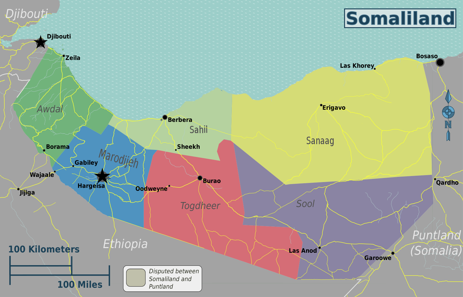
English: Somaliland regions map. English version, Somaliland
|
| תאריך יצירה | |
| מקור | File:Somaliland regions map.svg |
| יוצר | Peter Fitzgerald, OpenStreetMap [1] |
רישיון
הקובץ הזה מתפרסם לפי תנאי רישיון קריאייטיב קומונז ייחוס-שיתוף זהה 2.0 כללי.
- הנכם רשאים:
- לשתף – להעתיק, להפיץ ולהעביר את העבודה
- לערבב בין עבודות – להתאים את העבודה
- תחת התנאים הבאים:
- ייחוס – יש לתת ייחוס הולם, לתת קישור לרישיון, ולציין אם נעשו שינויים. אפשר לעשות את זה בכל צורה סבירה, אבל לא בשום צורה שמשתמע ממנה שמעניק הרישיון תומך בך או בשימוש שלך.
- שיתוף זהה – אם תיצרו רמיקס, תשנו, או תבנו על החומר, חובה עליכם להפיץ את התרומות שלך לפי תנאי רישיון זהה או תואם למקור.
יומן העלאה מקורי
| This file was imported from Wikivoyage WTS. |
תיאור הקובץ המקורי נמצא כאן. כל שמות המשתמשים הבאים מתייחסים ל-wts.wikivoyage-old.
- 2012-10-30 01:51 Peterfitzgerald archive copy at the Wayback Machine 3008×1928 (1130785 bytes) {{Imagecredit|credit=Peter Fitzgerald, OpenStreetMap [http://openstreetmap.org]|captureDate=29 October 2012|location=Somaliland|source=[[:File:Somaliland regions map.svg]]|caption=Somaliland regions map|description=English version}}{{Map|Somaliland}}
היסטוריית הקובץ
ניתן ללחוץ על תאריך/שעה כדי לראות את הקובץ כפי שנראה באותו זמן.
| תאריך/שעה | תמונה ממוזערת | ממדים | משתמש | הערה | |
|---|---|---|---|---|---|
| נוכחית | 01:40, 3 במאי 2021 | | 1,026 × 1,600 (556 ק"ב) | Siirski | update borders to show Sahil region and corrected eastern border |
| 21:03, 20 ביוני 2020 |  | 1,928 × 3,008 (1.08 מ"ב) | Kzl55 | Reverted to version as of 02:45, 18 November 2012 (UTC) Restored long-standing stable version, the map is of regions within Somaliland | |
| 19:07, 16 ביוני 2020 |  | 513 × 800 (296 ק"ב) | Meelpringthusss | highlighted disputed area | |
| 05:45, 18 בנובמבר 2012 |  | 1,928 × 3,008 (1.08 מ"ב) | MGA73bot2 | {{BotMoveToCommons|wts.oldwikivoyage|year={{subst:CURRENTYEAR}}|month={{subst:CURRENTMONTHNAME}}|day={{subst:CURRENTDAY}}}} == {{int:filedesc}} == {{Information |description=Somaliland regions map. English version, Somaliland * Map of: Somaliland¤ |da... |
שימוש בקובץ
אין דפים המשתמשים בקובץ זה.
שימוש גלובלי בקובץ
אתרי הוויקי השונים הבאים משתמשים בקובץ זה:
- שימוש באתר en.wikipedia.org
- שימוש באתר fr.wikivoyage.org
- שימוש באתר incubator.wikimedia.org
- שימוש באתר it.wikivoyage.org
- שימוש באתר vi.wikivoyage.org