
קובץ:NEO lake jau big.jpg

גודל התצוגה המקדימה הזאת: 600 × 600 פיקסלים. רזולוציות אחרות: 240 × 240 פיקסלים | 480 × 480 פיקסלים | 750 × 750 פיקסלים.
לקובץ המקורי (750 × 750 פיקסלים, גודל הקובץ: 134 ק"ב, סוג MIME: image/jpeg)
זהו קובץ שמקורו במיזם ויקישיתוף. תיאורו בדף תיאור הקובץ המקורי (בעברית) מוצג למטה
ויקישיתוף הוא מאגר תמונות וקובצי מדיה חופשיים. אתם יכולים לעזור. |
תקציר
| תיאור |
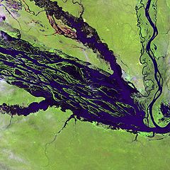
English: The Negro River flowing through the eastern edge of Brazil’s Jau National Park. The river is the big strip of blue running from left to right across the image, and the other blue ribbons are tributaries. Originating at the border of Venezuela and Brazil, the Negro River meets up with the Amazon in central Brazil to become its largest tributary. Half-submerged islands can be seen in the center of the river. Between November and April when the river is at its peak, many of these islands disappear. |
| תאריך יצירה | |
| מקור |
http://earthobservatory.nasa.gov/Newsroom/NewImages/images.php3?img_id=10843
|
| יוצר | NASA and USGS EROS Data Center Satellite Systems Branch |
רישיון
This image is in the public domain in the United States because it only contains materials that originally came from the United States Geological Survey, an agency of the United States Department of the Interior. For more information, see the official USGS copyright policy.
|
יומן העלאה מקורי
תיאור הקובץ המקורי נמצא כאן. כל שמות המשתמשים הבאים מתייחסים ל-en.wikipedia.
- 2003-11-23 05:55 Snoyes 750×750×8 (136760 bytes)
היסטוריית הקובץ
ניתן ללחוץ על תאריך/שעה כדי לראות את הקובץ כפי שנראה באותו זמן.
| תאריך/שעה | תמונה ממוזערת | ממדים | משתמש | הערה | |
|---|---|---|---|---|---|
| נוכחית | 23:27, 4 באפריל 2008 | | 750 × 750 (134 ק"ב) | File Upload Bot (Magnus Manske) | {{BotMoveToCommons|en.wikipedia}} {{Information |Description={{en|'''Credit(s):''' [http://edc.usgs.gov/ USGS EROS Data Center] Satellite Systems Branch. '''Source:''' http://earthobservatory.nasa.gov/Newsroom/NewImages/images.php3?img_id=10843 ''?The |
שימוש בקובץ
הדף הבא משתמש בקובץ הזה:
שימוש גלובלי בקובץ
אתרי הוויקי השונים הבאים משתמשים בקובץ זה:
- שימוש באתר ar.wikipedia.org
- שימוש באתר ast.wikipedia.org
- שימוש באתר ba.wikipedia.org
- שימוש באתר be.wikipedia.org
- שימוש באתר bg.wikipedia.org
- שימוש באתר ca.wikipedia.org
- שימוש באתר de.wikipedia.org
- שימוש באתר de.wikivoyage.org
- שימוש באתר en.wikipedia.org
- שימוש באתר es.wikipedia.org
- שימוש באתר eu.wikipedia.org
- שימוש באתר fr.wikipedia.org
- שימוש באתר he.wikipedia.org
- שימוש באתר hi.wikipedia.org
- שימוש באתר hr.wikipedia.org
- שימוש באתר id.wikipedia.org
- שימוש באתר it.wikivoyage.org
- שימוש באתר ja.wikipedia.org
- שימוש באתר ka.wikipedia.org
- שימוש באתר ko.wikipedia.org
- שימוש באתר lt.wikipedia.org
- שימוש באתר mai.wikipedia.org
- שימוש באתר ml.wikipedia.org
- שימוש באתר mt.wikipedia.org
- שימוש באתר ne.wikipedia.org
- שימוש באתר nl.wikipedia.org
- שימוש באתר pl.wikipedia.org
צפייה בשימושים גלובליים נוספים של קובץ זה.