
קובץ:Jerusalem-2013(2)-Aerial-Temple Mount-(south exposure).jpg

גודל התצוגה המקדימה הזאת: 799 × 600 פיקסלים. רזולוציות אחרות: 320 × 240 פיקסלים | 639 × 480 פיקסלים | 1,023 × 768 פיקסלים | 1,280 × 961 פיקסלים | 2,560 × 1,922 פיקסלים | 7,500 × 5,632 פיקסלים.
לקובץ המקורי (7,500 × 5,632 פיקסלים, גודל הקובץ: 40.97 מ"ב, סוג MIME: image/jpeg)
זהו קובץ שמקורו במיזם ויקישיתוף. תיאורו בדף תיאור הקובץ המקורי (בעברית) מוצג למטה
ויקישיתוף הוא מאגר תמונות וקובצי מדיה חופשיים. אתם יכולים לעזור. |
תקציר
| תיאור |
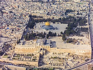
العربية: لقطة جويَّة جنوبيَّة للحرم القدسي الشريف، الواقع في بلدة القدس القديمة. يظهرُ في المُقدِّمة المسجد القبلي الذي يُخطئ الكثير من النَّاس ويعتقدون أنَّه المسجد الأقصى، ثالثُ أقدس الأماكن في الإسلام بعد المسجد الحرام والمسجد النبوي، في حين أنَّ هذا المُجمَّع بأكمله هو المسجد الأقصى. تظهرُ في الخلف قبَّة الصخرة وإلى يمينها قبَّة السلسلة، التي شُيِّدت خلال العهد الأُمويّ (حوالي سنة 685 للميلاد) واتُخذت نموذجًا لبناء قبَّة الصخرة (حوالي سنة. 691 للميلاد). يعتبرُ اليهود أنَّ هيكل سُليمان، وهو أقدسُ الأماكن في اليهوديَّة يقعُ أسفل المسجد الأقصى.
English: Southern aerial view of the Temple Mount (Hebrew: הַר הַבַּיִת, Har HaBáyit, Arabic: الحرم الشريف, al-Ḥaram al-Šarīf), showing, Al-Aqsa Mosque (Hebrew: הַר הַבַּיִת, Arabic: المسجد الأقصى المبارك) in the Old City of Jerusalem (Hebrew: העיר העתיקה, Arabic: البلدة القديمة). Annotated in the foreground is Al-Aqsa Mosque (Arabic: ٱلْمَسْجِد ٱلْأَقْصَى). Al-Aqsa Mosque is considered to be the third holiest site in Islam after Mecca and Medina. Behind are The Dome of the Rock (Hebrew: כיפת הסלע, Arabic: مسجد قبة الصخرة) and to the right, The Dome of the Chain (Arabic: قبة السلسلة, Qubbat al-Silsila), constructed during the Umayyad Caliphate (c. 685 AD) and served as a model for the building of the Dome of the Rock (c. 691 AD). The Temple Mount, which is called by Muslims Al-Aqsa Mosque, is considered to be the premier holy site in Judaism as it is the place where the first and second Temples stood.
עברית: מבט מדרום על הר הבית בעיר העתיקה בירושלים. בחזית רואים את מסגד אל-אקצה, שנחשב לשלישי בדרגת הקדושה באיסלם, אחרי מכה ומדינה. מאחור כיפת הסלע ומימין כיפת השלשלת, שנבנתה בתקופת חליפות אומיה ושימשה כמודל לבניית כיפת הסלע. הר הבית, עליו נבנה מסגד אל-אקצה נחשב למקום הקדוש ביותר ביהדות, כיוון שעליו נצבו בית המקדש הראשון והשני.
|
| תאריך יצירה | |
| מקור | נוצר על־ידי מעלה היצירה |
| יוצר | Godot13 |
| גרסאות אחרות | |
| ייחוס (required by the license) | Andrew Shiva / Wikipedia / |
.jpg)
.jpg)
.jpg)
.jpg)
.jpg)
.jpg)
,_2013_aerial_from_S_(cropped).jpg)
.jpg)
.jpg)
.jpg)
.jpg)
-Aerial-Temple_Mount-(south_exposure).jpg)
-Aerial-Temple_Mount-(south_exposure).jpg?uselang=he)
Türkçe: Tapınak Dağı'nın (İbranice: הַר הַבַּיִת, Har HaBáyit, Arapça: الحرم الشريف, al-Ḥaram al-Šarīf) güneyden havadan görünümü, Mescid-i Aksa'yı (İbranice: הַר הַבַּיִת, Arapça: المسجد الأقصى المبارك), Kudüs'ün Eski Şehri'nde (İbranice: העיר העתיקה, Arapça: البلدة القديمة). Ön planda El-Aksa Camii (Arapça: ٱلْمَسْجِد ٱلْأَقْصَى) gösterilmektedir. Mescid-i Aksa, Mekke ve Medine'den sonra İslam'ın en kutsal üçüncü mekânı olarak kabul edilir. Arkada Kubbet-üs Sahra (İbranice: כיפת הסלע, Arapça: مسجد قبة الصخرة) ve sağda Kubbet-üs Sahra (Arapça: قبة السلسلة, Qubbat al-Silsila), Emevi Halifeliği döneminde (yaklaşık MS 685) ve Kubbetü's-Sahra'nın (MS 691) inşası için bir model olarak hizmet etmiştir. Müslümanlar tarafından Mescid-i Aksa olarak adlandırılan Tapınak Dağı, birinci ve ikinci Tapınakların bulunduğu yer olması nedeniyle Yahudilikte en önemli kutsal alan olarak kabul edilmektedir.
| מיקום המצלמה | | תמונה זו ותמונות נוספות במיקום: OpenStreetMap |
|---|
-Aerial-Temple_Mount-(south_exposure).jpg¶ms=031.772558_N_0035.238153_E_globe:Earth_type:camera_heading:337.50&language=he)
הערכה
|
-Aerial-Jerusalem-Temple_Mount-Temple_Mount_(south_exposure).jpg)
-Aerial-Temple_Mount-(south_exposure).jpg)
-Aerial-Temple_Mount-(south_exposure).jpg)
-Aerial-Temple_Mount-(south_exposure).jpg)

|
This image has been assessed under the valued image criteria and is considered the most valued image on Commons within the scope: Aerial views of the Temple Mount, Southern view. You can see its nomination here. |
-Aerial-Jerusalem-Temple_Mount-Temple_Mount_(south_exposure).jpg)
רישיון
אני, בעל זכויות היוצרים על עבודה זו, מפרסם בזאת את העבודה תחת הרישיון הבא:
הקובץ הזה מתפרסם לפי תנאי רישיון קריאייטיב קומונז ייחוס-שיתוף זהה 4.0 בין־לאומי.
- הנכם רשאים:
- לשתף – להעתיק, להפיץ ולהעביר את העבודה
- לערבב בין עבודות – להתאים את העבודה
- תחת התנאים הבאים:
- ייחוס – יש לתת ייחוס הולם, לתת קישור לרישיון, ולציין אם נעשו שינויים. אפשר לעשות את זה בכל צורה סבירה, אבל לא בשום צורה שמשתמע ממנה שמעניק הרישיון תומך בך או בשימוש שלך.
- שיתוף זהה – אם תיצרו רמיקס, תשנו, או תבנו על החומר, חובה עליכם להפיץ את התרומות שלך לפי תנאי רישיון זהה או תואם למקור.

|
בעלי זכויות היוצרים על הקובץ הזה, Andrew Shiva, מאשרים לכולם להשתמש בו לכל מטרה, בתנאי שניתן לבעלי הזכויות ייחוס נאות. הפצה, יצירות נגזרות, שימושים מסחריים וכל שימוש אחר מותרים. |
ייחוס:
Use or reproduction of this image outside of Wikipedia must give the original photographer (Andrew Shiva) credit. Although not required, it would be appreciated if a message was left here indicating where this image was being used.
|
| Annotations | This image is annotated: View the annotations at Commons |
היסטוריית הקובץ
ניתן ללחוץ על תאריך/שעה כדי לראות את הקובץ כפי שנראה באותו זמן.
| תאריך/שעה | תמונה ממוזערת | ממדים | משתמש | הערה | |
|---|---|---|---|---|---|
| נוכחית | 02:50, 10 בדצמבר 2013 | | 5,632 × 7,500 (40.97 מ"ב) | Godot13 | Slight adjustment |
| 02:43, 9 בדצמבר 2013 |  | 5,632 × 7,500 (38.96 מ"ב) | Godot13 | User created page with UploadWizard |
שימוש בקובץ
שימוש גלובלי בקובץ
אתרי הוויקי השונים הבאים משתמשים בקובץ זה:
- שימוש באתר ace.wikipedia.org
- שימוש באתר af.wikipedia.org
- שימוש באתר als.wikipedia.org
- שימוש באתר ar.wikipedia.org
- الوطن العربي
- الإسراء والمعراج
- بوابة:آسيا/صورة مختارة
- بوابة:الإسلام/مقالة مختارة
- بوابة:الإسلام/صورة مختارة
- تهويد القدس
- محافظات السلطة الوطنية الفلسطينية
- المسجد الأقصى
- بوابة:تجمعات سكانية/صورة مختارة
- بوابة:تجمعات سكانية/صورة مختارة/2
- بوابة:القدس/صورة مختارة
- بوابة:فلسطين/مزار مختار/أرشيف
- بوابة:فلسطين/مزار مختار/1
- بوابة:الوطن العربي/صورة مختارة/أرشيف
- قائمة مساجد حول العالم
- قائمة آثار محافظة القدس
- ويكيبيديا:ترشيحات الصور المختارة/صورة جوية للمسجد الأقصى
- مستخدم:محمد كامل
- بوابة:الإسلام/مقالة مختارة/7
- بوابة:الإسلام/صورة مختارة/5
- معالم فلسطين
- ويكيبيديا:الويكي تهوى المعالم 2014/فلسطين
- ويكيبيديا:صور مختارة/أماكن/مناطق حضرية
- أحداث المسجد الأقصى 2014
- بوابة:العالم الإسلامي/صورة مختارة/أرشيف
- بوابة:العالم الإسلامي/صورة مختارة/20
- بوابة:العالم الإسلامي/معركة مختارة/أرشيف
- بوابة:العالم الإسلامي/معركة مختارة/9
- ويكيبيديا:صورة اليوم المختارة/مايو 2016
- قالب:صورة اليوم المختارة/2016-05-08
- بوابة:الوطن العربي/صورة مختارة/72
- ويكيبيديا:صورة اليوم المختارة/أغسطس 2017
- قالب:صورة اليوم المختارة/2017-08-01
- بوابة:القدس/صورة مختارة/3
- مستخدم:Mohammad Hijjawi/مسودة مقال البلدة القديمة
- بوابة:مساجد/مسجد مختار/أرشيف
- بوابة:مساجد/مسجد مختار/3
- بوابة:مساجد/مقولة مختارة/أرشيف
- بوابة:مساجد/مقولة مختارة/3
- القيود المفروضة لدخول المسجد الأقصى
- ويكيبيديا:صورة اليوم المختارة/يوليو 2019
- قالب:صورة اليوم المختارة/2019-07-03
- تاريخ القدس
- مآذن المسجد الأقصى
- ويكيبيديا:صورة اليوم المختارة/أبريل 2021
צפייה בשימושים גלובליים נוספים של קובץ זה.
-Aerial-Temple_Mount-(south_exposure).jpg)
-Aerial-Temple_Mount-(south_exposure).jpg)